key-principles-banner-min (1) (1)

Key Principles

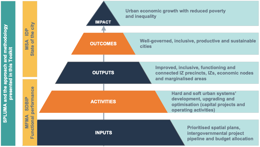
The approach, methodology and techniques presented in this Toolkit are supported of and consistent with the following two sets of principles:

  • Spatial planning principles articulated in the Spatial Planning and Land Use Management Act (SPLUMA); and
  • Principles for spatial planning, implementation and urban management developed in response to the National Development Plan (NDP), the Integrated Urban Development Framework (IUDF), the Urban Network Strategy (UNS) and the BEPP process developed between National Treasury and metros.
These 10 principles are – click on any principle to find out more:
Spatial justice
READ MORE
Spatial sustainability
READ MORE
Spatial efficiency
READ MORE
Spatial resilience
READ MORE
Good administration
READ MORE
Outcomes-led planning
READ MORE
Beyond consultation to active involvement
READ MORE
Follow through with robust urban management
READ MORE
Climate resilience & response
READ MORE
Co-management
READ MORE
Spatial justice
READ MORE
Spatial sustainability
READ MORE
Spatial resilience
READ MORE
Spatial efficiency
READ MORE
Outcomes-led planning
READ MORE
Good administration
READ MORE
Beyond consultation to active involvement
READ MORE
Follow through with robust urban management
READ MORE
Climate resilience & response
READ MORE
Co-management
READ MORE
Scroll to Top
Spatial justice

Spatial justice is a principle established in SPLUMA.  Key requirements to give effect to the principle of spatial justice include:

  • Address past spatial and other development imbalances through improved access to and use of land, including by disadvantaged communities and persons
  • SDFs and policies must address the inclusion of persons and areas that were previously excluded (informal settlements, former homeland areas and areas characterised by widespread poverty and deprivation)
  • Land use management (LUM) systems must cover the entire municipality and include flexible and appropriate provisions for disadvantaged areas, informal settlements and former homeland areas
  • Accommodate access to secure tenure and the incremental upgrading of informal areas
  • Applications may not be impeded or restricted solely on the ground that the value of land or property is affected by the outcome of the application
Spatial sustainability

Spatial planning and land use management systems must-

  • Promote land development within the fiscal, institutional and administrative means of the Republic
  • Protect prime and unique agricultural land
  • Uphold consistency of land use measures in accordance with environmental management instruments
  • Promote and stimulate the effective and equitable functioning of land markets
  • Consider all current and future costs to all parties for the provision of infrastructure and social services in land developments
  • Promote land development in sustainable locations and that limit urban sprawl
  • Result in communities that are viable
Spatial efficiency

Requirements for spatial efficiency include:

  • Land development optimises the use of existing resources and infrastructure
  • Decision-making procedures are designed to minimise negative financial, social, economic or environmental impacts
  • Development application procedures are efficient and streamlined, and timelines are adhered to by all parties
Spatial resilience
Spatial plans, policies and LUM systems must be flexible to ensure sustainable livelihoods in communities most likely to suffer economic and environmental shocks.
Good administration

Good administration requires:

  • Integrated approach to land use and land development by all spheres of Government
  • All government departments must provide their sector inputs and comply with prescribed requirements during the preparation/amendment of SDFs
  • The requirements of any law relating to land development and land use must be met timeously
  • Spatial planning and land use management processes to include transparent public participation processes
  • Policies, legislation and procedures must be clear to inform and empower members of the public
Outcomes-led planning

As noted in Section 1.2, spatial planning and transformation should result in the outcomes of well-governed, inclusive, productive and sustainable cities, resulting in urban economic growth with reduced poverty and inequality (the impact). Planning efforts must be directed towards the achievement of clearly articulated outcomes, and subsequent resource allocation inclusive of budget allocation, activities and outputs must be directed towards achievement of those stated outcomes. This outcomes-based approach is evident in the NDP, the IUDF and is a model advocated by the Department of Performance Monitoring and Evaluation (DPME). This requires:

  • Line of sight. Spatial plans must clearly demonstrate how they will contribute the desired outputs, outcomes and impact;
  • Attention to implementation. Spatial plans must incorporate practical, measurable programmes, projects and activities to generate the required outputs and outcomes;
  • Costed, tested and budgeted. Programmes, project and activities must be costed, their financial viability tested, and reflected in budget provision in all of the intergovernmental entities involved, including in the budget of the city; and
  • Checking. Continuous monitoring and evaluation are required to ensure that plans are implemented as planned, and that the outputs and outcomes are generated.
Figure: Outcomes-led planning
Beyond consultation to actual involvement

The scale of urban spatial transformation requires extensive consultation, buy-in, commitment and investment by the municipality, the public sector at large, State-Owned Enterprises (SOEs), the private sector, Non-Governmental Organisations (NGOs) and other interest groups.


The NDP recognises that spatial transformation is a long-term project, and case studies from around the globe confirm that large-scale urban regeneration and upgrading projects can take between 10 to 25 years from conceptualisation to full built-out. Throughout this period many dynamics may unfold that may threaten the path chosen. These include changing of the city political guard and senior leadership, waning public and investor interest due to the timespan involved, changing social preferences, the disrupting impacts of technology, changes in the economic structure that may lead to sectoral shifts in the economy that may affect land use utilisation and real estate dynamics, and a host of other factors.

To overcome these challenges, all of society must be engaged in initial consultation and selection of the appropriate solutions and designs, and as far as practicality possible, they must be engaged on an ongoing basis throughout the implementation of the solution. This requires:

  • Identification of all stakeholders and extensive, meaningful consultation and participation. Consultation should not be held only because it is a legal requirement, cities should attempt at actively engaging stakeholders in seeking appropriate solutions. In some instances, planners are obligated to not only consult stakeholders, but to actively involve them in the planning process and beyond2. Beyond any existing obligations, involving stakeholders in especially urban design increases urban participation and democracy, offers the value of experience and insight into the norms, perspectives, desires, needs and aspirations of various groups, strengthens the sense of shared ownership of ideas and spaces, and establishes the foundations for eventual community pride and a sense of belonging.
  • Robust but flexible spatial plans that stand the test of time. Precinct plans and integration zone plans that apply robust spatial structuring principles and that incorporates best practice principles such as connectedness through public transport, inclusivity, multiple land use, higher density development and climate change adaptation, are more likely to remain valid and response over longer periods of time. At the same time, softer urban system arrangements, such as zoning controls and building design, should be suitably flexible to accommodate changing economic, social and technological conditions and preferences.
  • Robust urban designs, supported by 3D renderings. Visual demonstration of the proposed urban solutions supported by 3D renderings that help stakeholders, decision-makers and investors to clearly visualise the outputs are invaluable tools in generating interest and securing support for the spatial proposals presented. Another benefit of robust urban designs complemented by 3D renderings is that they demonstrate that the city has a clear vision and plan, have committed resources to generate these, and can readily move to the implementation phase.
  • Active engagement beyond plan adoption. Where possible, all stakeholders that will be affected and whose active support is required, should be involved throughout the project lifecycle.
  • Ongoing marketing. To ensure ongoing support for the project, and to garner support from subsequent generations of political leadership, senior management, constituents and other stakeholders, the project must be marketed on an ongoing basis, and incremental progress and successes communicated and celebrated.
Follow-through with robust urban management
Good spatial planning and urban design, and the implementation thereof, creates the physical environment for transformed urban spaces. Important as this is, it is not enough. Active urban management is required to fully realise the benefits of transformed urban spaces, and to reduce the scope for negative conditions that plaque many urban spaces.

One example of the importance of follow-through across the BEVC is that of precinct safety from crime. Urban design can do much to shape the physical environment into defensible space. The figure below demonstrates some urban design features coupled with building design and land use management that creates defensible space.

Figure: Precinct safety through urban design

This figure demonstrates the following:

  • Buildings on both sides of the street are oriented to provide street and sidewalk visibility, providing opportunities for natural surveillance by residents in addition to CCTV surveillance;
  • There is a mix of land uses that improves potential for around the clock human legitimate human activity and surveillance;
  • Surveillance is further enhanced by street lighting that illuminates both sidewalks and road verges where vehicles park; and
  • Sidewalks are sufficiently wide to promote active foot traffic and the higher density development coupled with mixed land use increase foot traffic – both wider sidewalks and busy sidewalks have been shown to reduce public space criminal activity.

These are important design features, but address only some precinct safety issues and, of themselves, they create the need for urban management activities. For example, installing streetlights require periodic replacement of light bulbs and CCTV camera capabilities require security staff to monitor video feeds and report suspicious and criminal activity.

The figure on the right demonstrates key elements to be addressed to respond to precinct safety in a comprehensive manner.

This figure shows the range of planning, urban design and urban management measures required to comprehensively provide precinct safety from crime.

Clearly, a whole range of precinct management activities, interventions and conditions, all of which form part of the ambit of urban management, are required to ensure safety in addition to good spatial planning and urban design.

Figure: Comprehensive response to precinct safety and security from crime

Some of these include:

  • Regulation and enforcement. Deciding precinct rules to regulate public safety and minimise anti-social and criminal behaviour, such as regulations relating to the public consumption of alcohol, and then enforcing those rules;
  • Territoriality that involves residents emotionally connecting with their space, and taking active interest and measures in protecting that space, such as by marking areas with signs indicating acceptable and unacceptable behaviour;
  • Access control and surveillance by limiting access to people with legitimate interests in the area or building, as well as surveillance to deter and detect suspicious or criminal activity;
  • Activity support, citizen engagement and programmes. The environment should be used by legitimate users, citizens must be empowered and connected, and programmes created to constructively engage the youth and other groups at risk of veering towards potential anti-social behaviour or criminal activity; and
  • Image and maintenance. The overall physical state of an area indicates the level of control, pride, interest and commitment to protect their environment. This requires property owners to actively care for and maintain their properties as well as the public realm.
Climate resilience and response
Climate change adaptation directly relates to the outcomes of productive and sustainable cities, but ultimately affects all urban outcomes and the desired impact of inclusive urban economic growth. Case studies of urban regeneration and upgrading initiatives in other developing countries such as the Two Rivers Development in Nairobi (Kenya), Beirut CBD and Waterfront (Lebanon), and Sabarmati Riverfront in Ahmedabad (India) revealed the following:
  • Integrating climate change and environmental enhancement in a holistic manner attracts investors, residents, shoppers and tourists to those precincts, and generate positive spill over effects into neighbouring areas. Done right, comprehensive integration of climate change adaptation in urban design, infrastructure solutions and in urban management not only create resilient precincts, they also contribute meaningfully to attractive, vibrant precincts with improved public realms and building fabric.
  • Climate responses should be multi-faceted and responsive to the risk exposure of the precinct as determined in climate risk zone assessment. Multiple tools to respond to climate change adaptation are available and these should be designed in the spatial planning phase and refined where necessary in the implementation phase. The figure below demonstrates the scope of climate change responses implemented in recent urban precinct projects in several developing countries:
Urban spatial transformation of key nodes, intervention zones and marginalised areas provide cities with the opportunity to proactively identify climate risk zones, and to develop and implement climate resilient solutions to future proof cities.

Climate risks will likely continue to evolve. Solutions or climate mitigation measures implemented during spatial transformation can be monitored, reviewed and improved or augmented through ongoing urban management.

Accordingly, this Toolkit considers climate change as a central objective to be pursued throughout the BEVC from spatial targeting and planning to programme design and securing green financing, implementation through to urban management.

The CSP of the National Treasury with technical support from the CSIR developed guidelines for mainstreaming climate change into metropolitan planning, following the process illustrated in the diagram below:
Figure: Array of precinct climate adaptation measures
Figure: Process for mainstreaming cliate change in metropolitan planning
Climate change resources
CSIR. 2022. Guideline on Mainstreaming Climate Responsiveness and Resilience into Metropolitan Planning. Published online by the Cities Support Programme of the National Treasury. Department of Forestry, Fisheries, and the Environment (DFFE). The National Climate Risk & Vulnerability Assessment Framework. Water Research Commission. 2020. Water Sensitive Land Use Management Guidelines. The GreenBook (www.greenbook.co.za)
Co-management
Urban management is not the sole responsibility of municipalities. As demonstrated in the example of precinct safety against crime, it requires the active involvement and participation of property owners, residents and other parties such as neighbourhood watches and block watches.

Sharing responsibility for urban management increases urban participation, democracy and responsibility, fosters community spirit and the creation and strengthening of social networks. When urban management models such as City Improvement Districts (CIDs) are chosen, it further alleviates financial and operating pressures on the municipality. Co-management arrangements cannot be left to social partners at the end of precinct creation or revitalisation. Such partners must be identified in the spatial planning phase and actively roped in decision-making and implementation processes.